AIS (Automatic Identification System)
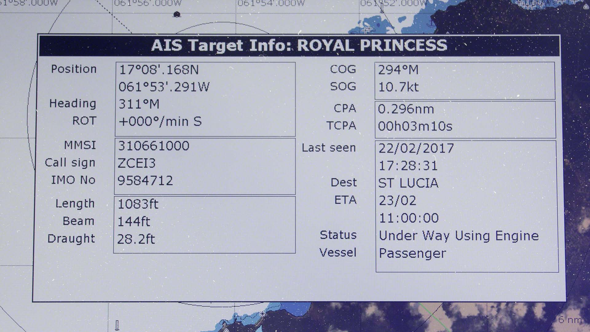
The AIS location tracking system is a great tool. All vessels over 300 gross tons or that are commercial passenger vessels are required to have (and use) a Class A AIS system. This digitally broadcasts information such as MMSI number, speed, and heading. Large ships use ECDIS systems, and smaller ones use chart plotters to track this data. It helps plot courses to avoid vessels in busy areas and bad visibility, and is used to prevent collisions. Class B systems send data at lower power and less frequently and are intended for smaller vessels that are not required to have AIS but wish to have it. This is the system I’ve got on board, and I consider it one of my most essential safety systems, if not the most important.
Usage
I’ve got a transmitter on board (a Raymarine 650), which runs all the time, even at anchor. My alarm went off while I was at sea, warning me of a CPA (closest point of approach) of under 5nm with a cargo vessel in 40 minutes; I couldn’t even see the cargo on the horizon at the time. After about 10 minutes, I rechecked the AIS and saw that the cargo ship had changed course to increase our CPA! Nominally, I am the “stand on” (right-of-way) vessel as a sailboat, but the reality is often quite different. I’m pleased with AIS; not only is it an important safety device, but it’s also fun to get boat names and speeds when the boats are just a bit too far away to make out the names.
Tracking
There are several sites online that offer free AIS tracking. The broadcast signals are collected by volunteers using receivers that receive terrestrial signals and feed the websites with that data. There are also satellite receivers, but those services are geared towards fleets of commercial vessels and are pricey. Many of the anchorages and areas I frequent are out of the volunteers’ reception range. This means that the free location services all show “Pleasure Craft. Position received by satellite” rather than the boat name. If I want to be seen and recognized on the internet, I’ll use an app for MarineTraffic. This lets me self-broadcast the AIS information. Which assumes that I’ve got my StarLink turned on and broadcasting.
Below is the current location of Zanshin according to MarineTraffic.Com. If nothing shows on the map, then my AIS is either turned off or temporarily out of range.